Giant waterfalls, colonial ambitions, government schemes that do the opposite of what was intended, and an encrypted World War 2 document from the secret police: for a historian, South American politics and environmental conservation are fertile ground.
Intrigued? We were too. That’s why we took the opportunity to talk with Frederico Freitas about his new book, “Nationalizing Nature: Iguazu Falls and National Parks at the Brazil-Argentina Border.” Freitas is an assistant professor of digital and Latin American history at NC State. (And if you want to hear about the encrypted document, you’ll have to read our interview – it didn’t make it into the book.)
The Abstract: Your book examines the various roles that national parks have played along the border of Brazil and Argentina, starting with when they were established in the 1930s. What drew you to this subject?
Frederico Freitas: I was in my second year in the Ph.D. program in Latin American history at Stanford University, and I needed to define a topic. I applied to Stanford to do research on environmental history, and I knew I wanted to do something related to the history of deforestation in Brazil. (I am from Brazil originally.)
Brazil is huge, larger than the contiguous United States. So, to define my topic, I had to first find a specific area within the country and a time period. In this brainstorming process, I recalled a trip I made while touring with a punk rock band in South America in the early 2000s. At some point on that trip I had to cross the border, entering Brazil from Argentina. I remember being struck by the sharp contrast between the two sides of this border. The Argentine side was still totally covered by forests. But when I entered Brazil, the only thing I saw was croplands. It dawned on me that a border area would be a great place to understand the process of deforestation in Brazil in the 20th century.
That border region, which is known locally as the “Triple Frontier,” was even more interesting because it harbored a third country sharing international boundaries with Brazil and Argentine, Paraguay. So, I set myself up to write an environmental history of this tri-border area.
Before the 20th century, the entire region was covered with subtropical forests. There was little difference between the various sides of this borderland. Jump to 1960, and you see the landscape at the Brazilian side of the border already converted into farms and cities. Argentina and Paraguay, however, were still covered by forests (although in Argentina, some of these forests were planted for industrial uses). Jump again to the present. The Paraguayan side of the border has followed Brazil’s path and is mostly taken up by crop production. Argentina, however, is still relatively forested. These various stages of land cover change across both time and different sides of the border seemed an ideal case study to understand and compare the process of deforestation in these three countries.
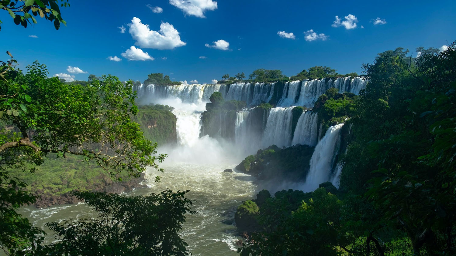
However, as I started doing preliminary research on this project, I noticed these enormous patches of forest that seemed impervious to the changes happening outside them – logging, deforestation and conversion to agriculture. These forested patches were the Iguazú National Park in Argentina and the Iguaçu National Park in Brazil, two of the oldest national parks in Latin America (created between 1934 and 1939). They are known for harboring the world-famous Iguazu Falls. But they extend inland far beyond the falls, a fact that is not known by the majority of the millions of tourists who visit the falls every year. How did these parks manage to preserve the forest? Latin America is full of examples of protected areas where the protections are never actually implemented.
I was intrigued.
I decided to shift my focus to the parks themselves. They would offer me a clear narrative thread from which I could analyze changes at the borderland and the evolution of territorial and conservation policies in these two countries.
TA: And what made you decide this was something you wanted to pour yourself into for a years-long book project?
Freitas: I did not have much of a choice. Years-long book projects based on extensive archival research is the standard form of producing knowledge in academic history. Historians prize deeply researched long-form monographs that take years to complete. That does not mean historians do not produce short articles. They do. But the book form is the gold standard for delivering research within the discipline. It is different from other fields, economics or political science for example, where it makes sense to publish in articles research that speaks directly to the order of the day. Historians provide new insight on what already happened, and the past is not going anywhere. So we have time to dive deeper into specific topics.
TA: History often gives us powerful insights into the present. What makes the history of these parks so timely today?
Freitas: The history of these parks is so timely because it offers parallels to things happening right now. Just to give Brazil as an example, in recent years, the international community has witnessed the alarming growth of deforestation in the Brazilian Amazon and the Bolsonaro administration’s refusal to do anything about it.
In 2019, for example, ranchers set several protected areas in the Amazon ablaze in a coordinated effort to undermine the country’s environmental protection system. The recent history of the Brazilian Amazon is marked by the advance of the settlement frontier and the attempts by different Brazilian administrations to curb such advances by creating protected areas and indigenous lands.
The national parks in my book are not in the Amazon rainforest – they were established far away in the south, at the border between Brazil and Argentina. But the region where they are located experienced a similar process of frontier expansion, deforestation and conversion to agriculture in the 1950s and 1960s. And yet the parks there, which were created before the arrival of most settlers to the region, managed to withstand these changes. They left this border area with enduring patches of subtropical forests. In an era of climate change, these densely forested preserves are increasingly crucial as carbon sinks. Thus, I believe that understanding the Iguazú and Iguaçu parks’ history can give us insight into the present – and future – of other forested areas in Latin America. One of the main insights is that, at least in Brazil and Argentina, the state was capable of enforcing the laws that established these parks as protected areas when it invested resources to do so.
TA: What were Brazil and Argentina trying to accomplish when they created these parks in the 1930s?
Freitas: This is where things get interesting when you look at the past – a lot of time, you find people were doing things for surprising reasons.
When you study the history of national parks in the United States, the country that created the first national parks, you see a story of parks being created to preserve wilderness for the public and future generations. The United States established its first national parks in the West in the late 19th century. One of the new parks’ justifications was to prevent settlement in desired landscapes such as the Yellowstone Caldera or the Yosemite Valley. Things were quite different at the Brazil-Argentina border in the 1930s.
In this area, the two countries shared a geological feature they wanted to preserve, the majestic Iguazu Falls, located right at the two countries’ border. But each country also wanted to promote the settlement of their side of the border. The area was still sparsely populated and covered with forests in the 1930s when the parks were created. Each country feared that an influx of immigrants from across the border could threaten their hold of this frontier area. So they adopted a policy of using the national parks to promote colonization with their own citizens on their sides. In a way, Brazil and Argentina used parks to do the opposite of what the United States had done with its parks. They used parks to attract settlers from their densely populated Atlantic seaboards to populate these sparsely inhabited borderlands. Argentina and Brazil pioneered national parks as tools of frontier development and border control. Brazil already had a colony it had founded in the late 19th century close to where it would establish its park, the town of Foz do Iguaçu. So Brazilian authorities funneled national park funds into a series of infrastructure works that had nothing to do with conservation and tourism, but that would attract settlers. They built highways, airports, hospitals, power plants. Argentina was even more radical in its approach, reserving a section inside its national park to create a town for settlers. The Argentina national park service would end up selling plots of land to incoming settlers inside its park, a policy repeated in other border parks throughout the country.
TA: But by the 1970s, military regimes in both countries were effectively waging war on settlers in those parklands. Why was that? What happened between the 1930s and the 1970s?
Freitas: During this period, four things happened that helped to turn the tide against the settlers who were living inside parklands. First, there is a generational change inside the national park agencies in both Brazil and Argentina. This new generation of government officials opposed the idea of having people living inside national parks. The second change is the formation of an international consensus about what constituted a national park. In the 1950s and 1960s, conservationists and organizations such as the International Union for Conservation of Nature (IUCN) started promoting a narrow definition of national parks. This new definition included the notion that people should not live inside these protected areas. Such an idea impacted Latin America, particularly Argentina. The country decided to remove settlers from its parks and retrace park boundaries to separate the towns and farms it had established from their protected areas.
Another change was in the status of the borderland itself, which was more relevant to Brazil. In the 1960s and 1970s, much of the area outside the Iguaçu National Park in Brazil had been settled by farmers from other parts of the country. Government officials no longer feared losing control of the borderland in case of an influx of immigrants from neighboring countries. Finally, the political context provided park authorities with the tools to swiftly remove settlers from the parks. Brazil and Argentina spent most of the 1960s and 1970s under the rule of military dictatorships. The national parks agencies used authoritarian tools established during these years – from legislation for the relocation of people to extra-judicial intimidation methods – to remove settlers from the two parks. By 1980, the two border parks had, together, removed about 6,000 settlers from their territories.
TA: Your work draws, in part, on remote sensing research to shed light on changes in the landscape of these parks – and what drove those landscape changes. What did your research uncover?
Freitas: The remote sensing study focuses on the Brazilian national park, the larger of the two parks. It is based on aerial imagery produced by the local state government in the 1950s and 1980s, plus historical satellite imagery generated by the Corona program, a series of U.S. spy satellites launched in the 1960s. The remote sensing study helped me to understand a series of essential processes.
The first is the timeline of settler occupation inside the Brazilian park. Unlike Argentina, Brazil never officially allowed settlers inside their parks. Still, for a series of reasons that I discuss at length in the book, settlers ended up occupying the park anyway. The remote sensing study helped me understand that settlers entered the park mostly between the late 1950s and late 1960s, decades after the park was established. It also showed that the process of settler removal that started in 1970 had, in fact, actually attracted more settlers to the national park. Specifically, when the news of possible compensation from the government spread in the communities outside the Brazilian park, some people decided to squat on parklands in hopes of being expelled and claiming such benefits.
I also used remote sensing to measure the area affected by settlements inside the park. I calculated how much forest had been regrown inside the national park since the settlers’ removal in the 1970s. Finally, remote sensing allowed me to understand changes outside the Brazilian park and the pace of deforestation in the region. I saw that the area outside the park reached the apex of deforestation in the 1980s. Since then, there has been an increase in reforested patches inside farms due to greater enforcement of conservation laws in the late 1990s and early 2000s.
TA: After spending so long working on this project, are there any key themes or ideas that really stuck with you from the work?
Freitas: One of the main themes in my research is the importance of nationalism and geopolitics in the making of these two parks. When park boosters in Brazil and Argentina started lobbying to create these two parks before the 1930s, their goal was to beat the neighboring country in being the first to establish a national park on their side of the border. Each side wanted a national park to claim their share of the binational Iguazu Falls. This attitude, where park authorities in the two countries saw the parks as the last line of defense against their international neighbor, continued in different ways, all the way to the present. Such geopolitical reasoning justified the use of the parks as tools for frontier colonization by the two countries. This mentality was also present in the 1970s, when Argentina and Brazil’s military dictatorships suppressed resistance to settler removal. The military framed its actions as a matter of national security due to the parks’ location at a sensitive international border.
TA: One last question. When historians work on book projects, they pore through hundreds of sources – letters, diaries, reports, news stories, etc. – and find all sorts of wonderful facts that don’t necessarily fit into the book. What’s the most bizarre, interesting or humorous fact that you uncovered that didn’t make its way into the book?
Freitas: One of the most interesting anecdotes that is not in the book comes from a document that I got from the secret police archives in Brazil. It was a 1943 cable received by the local secret police office at the border. The document seemed promising, but there was a problem: the text was encrypted. It struck me that it was one of the few encrypted documents I ever found in this archive. The document was in a folder with other cables that talked about Nazi infiltration from Argentina. I thought breaking its code would uncover some unheard conspiracy about Nazis in South America at the height of WWII.
When the cable was sent, Brazil had sided with the Allies and declared war against Germany. Argentina, on the other hand, was officially neutral but close to the Axis. I have no training in cryptography and had no idea how to break the code, so I did the most obvious thing: I asked the internet to do that for me. I posted the cable on Twitter, asking if anyone could help me with that encrypted message. A month later, a random anonymous user whom I had never met before managed to decrypt it. Unfortunately, the cable revealed to be rather banal – it was an inquiry on whether the local customs had apprehended contraband coffee crossing the border to Argentina.
Editor’s Note: If you’d like to learn more about “Nationalizing Nature,” Freitas has written about it for the Cambridge University Press blog and on his own site. He has also made interactive maps related to his remote sensing research.
This post was originally published in NC State News.
- Categories: